


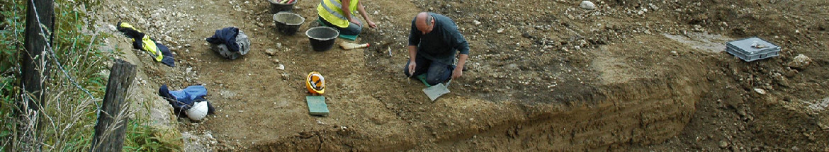
The present volume, fourth in a series of five devoted to the Merovingian hamlet of Develier-Courtételle (Canton of Jura, Switzerland), presents environmental information obtained through a series of specialised analyses of material found at this archaeological site and in its surroundings. The results of these six distinct approaches are integrated in a final synthesis.
A description of the natural environment of the site enriched with information from historical sources opens the volume (chap. 1). Situated within the Delémont basin in north-western Switzerland, in the central part of the Jura mountain range, Develier-Courtételle lies on a flood plain at an altitude of 450 m. The site covers a surface of 3,5 ha and lies on the banks of the brook "La Pran", in a lateral valley filled with quaternary sediments dating from the Würm glacial maximum to the Late Holocene. The sedimentary approach which follows this introductory chapter is based on a description of the stratigraphy (chap. 2). The site is divided into eight different domains and composite stratigraphic cuts are used to explain the extension of the different layers. The sediments are characterised using Passega's method, i.e. the construction of C/M patterns of the alluvial deposits. This analysis permits us to propose a reconstruction of the palaeogeography of the site, including some observations on the nature of the soils. The palaeo-hydrological and climatic fluctuations occurring locally between 500 and 800 AD are also described. Additional relevant data are provided by an "off-site" sedimentological analysis undertaken at Delémont, La Communance (chap. 3). It provides a palustrine sequence dating from the 6th to the 11th century and documenting the evolution of the local hydrology.
The three following chapters present the archaeobotanical approaches. The pollen analysis documents the changing landscape around the site and the use of the land by the Early Medieval population (chap. 4). The study of seeds and fruit reveals the large spectrum of plant species that were cultivated during this period (chap. 5). The vegetational landscape surrounding the site and the human impact on it can be reconstructed from the remains of wild plants. A geobotanical approach is used to deduce the spatial distribution of woodlands and fields around the site during the 7th century by looking at modern vegetation (chap. 6). The last analysis presented in this volume is the study of the faunal remains recovered in and around the settlement which reveal the dietary choices made by the inhabitants (chap. 7). The varying frequency and age at death of the different species of domesticates say much about animal husbandry during the Merovingian period. The rare remains of hunted wild animals were also identified.
The concluding synthesis is divided into three thematic sections (chap. 8). The climatic context and the evolution of the landscape during the Early Medieval period are the subject of the first section. A short summary of current knowledge introduces the chronological reconstitution of events deduced from the preceding analyses. At Develier-Courtételle, hydrological activity is quite sustained before 550. Forest cover is still relatively dense and actually expanded during Late Antiquity. From 550 to 750, the hydrological activity at the site becomes very intense, peaking around 580 and 650. At La Communance, the hydrological balance is at this time in surplus. From the beginning of this phase, forest cover diminishes ; this clearance was caused by the intensification of agriculture and the appearance of ironworking. As a result, erosion cuts ravines into the slopes. Several factors indicate a cool and possibly wet phase affecting the whole region which correlates well with data from other studies. The period between 700 and 830-890 appears to be a transition towards a somewhat dryer climate, a decrease of hydrological activity persisting after 800 could be observed on the site. At La Communance, the hydrological balance becomes negative only after the middle or towards the end of the 9th century. Forest cover does not vary to any major extent. The climate continues to improve between 830-890 and 1000 : several swamps and marshes in the region appear to have experienced a negative hydrological balance during this time and superficial sediments undergo pedogenesis. The rupture of the landscape equilibrium occurring during the later Middle Ages is thought to be due to the increasing impact of human activity, in particular ironworking.
The second theme of the synthesis is the landscape surrounding the settlement during the 7th century. A pictorial reconstruction allows us to conclude that the divisions of the territory are largely based on the meanders of the stream. To the inhabitants, the advantages of being close to the water necessary for various craft activities clearly outweighed the real risks posed by flooding. The marshy surfaces directly abutting on the settlement were good pasture but not useful for agriculture ; the fields were situated somewhat further away. The transition from cultivated land to forest occurred gradually and gave the landscape a structured appearance. The forest, dominated by beech and pine, is transformed by the selective exploitation of plant resources. It too is used for pasture.
A discussion of available resources and land use closes the volume. The stream could not have been used for transporting cargo. Used land surfaces included fields, pastures and grasslands. Cereals and legumes were the primary crops, oily or fibrous plants were of secondary importance and fruit and vegetables appear to have formed only a relatively minor source of food. Supplying the needs of the settlement seems to have been the principal goal of these activities, a characteristic of subsistence agriculture. Textile production occurred but was not very extensive. The forests and hedges are a source of timber, but particularly of firewood. Among the domestic animals, cattle are dominant and seem to have mostly been raised for meat, a part of which may have been exported. Goats and especially sheep are the next most important group according to the bone counts. The pigs are in third position but were actually in second place in terms of meat production. Fowl, mostly chicken, were principally kept for the eggs. The diverse wild fauna was nutritionally a very minor factor but is a good indicator of the natural environment surrounding the site. The presence of deer and bear speaks of nearby biotopes not yet disturbed by human activity.
Translation: Robert Fellner

CAJ 16 - Abstract
 Imprimer


Copyright © jura.ch - 2024